
Keeping NYC Moving: How Machine Learning Can Lead to Sustainable and Mobile Cities
Currently 54% of the world’s population lives in cities and this is expected to increase to 66% by 2050.[1] With all these new dwellers, innovation is not just needed but expected, particularly in mobility. This simple but challenging task is executed in a variety of ways depending on city size, population and infrastructure. New York City, constrained by an extensive underground subway and utilities network as well as predetermined city limits, has already begun leveraging machine learning to enhance its mobility networks.
New York City is comprised of 5 counties connected by over 6,000 miles of streets and highways, 12,000 miles of sidewalk, 794 bridges and tunnels plus ferries.[2] The New York City Department of Transportation (DOT), comprised of over 5000 people and an annual budget of 900 million, is responsible for maintaining and enhancing this network, serving over 9 million New Yorkers and 60 million annual visitors. With a population that large and growing the DOT needs a way to plan for a sustainable future.
In an effort to serve and secure this large population DOT is investing in data collection, data scientist and big data to algorithmically plan for mobility patterns. New York City has already started with a few innovative ways to collect data, such as metered parking apps, Citi bikes, and smart traffic control systems. Very new to New York is the ability to pay for parking via mobile device instead of using the traditional meter. The analytics collected are applied to a predictive algorithm to allow city planners to understand the ebbs and flows of traffic, who is driving into the city, where traffic congestion is increasing as well as predict the need for future capital expenditures like road repavement. Additionally, the app is also used to help drivers find parking spots that are available, thus reducing idle time and carbon emissions.
The Citi bikes initiative, a docked bike-sharing program, when piloted and pitched was heavily focused on providing a healthy and environmentally friendly alternative to the over crowded subway and environmentally unfriendly cabs. Furthermore, it provides key insights into traffic flow, where riders ride as well as what days of the week are most rides taken. Understanding that thousands of people daily are crossing Central Park by bike or commuting over the Williamsburg Bridge, ensures that DOT can make bikes available to communities that use them, prioritize the creation of bike lanes, as well as plan for space allocation and large-scale capital projects[3]. As the city is in the earliest stages around hiring data scientist, they have made large scale data sets available to the public. The city can then benefit from private business research conducted by students and businesses.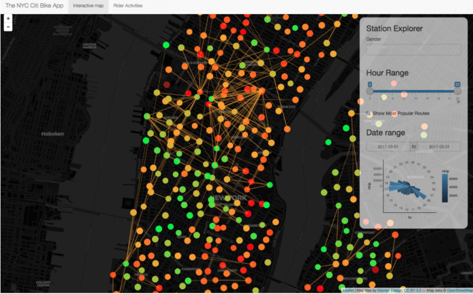 [4]
[4]

An additional and truly innovative data collector is the smart traffic signal systems. Previously traffic cameras collected speed violations for local agencies to monitor, analyze and ticket violators over the mail. Yet under new smart systems, the current traffic cameras in New York have sensors that are able to collect data on the number of cars and trucks that pass through an intersection and any current delays. It then communicates in real-time, allowing the entire system to react, diverting traffic from congested areas, and timing lights to reduce wait time and therefore reduce emissions.[5] As better technology becomes available, such as the adaptive traffic lights described in Sidewalk Lab’s City of the Future Podcast “Adaptive Traffic Lights,”[6] lights armed with cameras will be able to not just measure vehicular traffic but also bikes and pedestrians in real-time and decide who gets prioritized at the intersection.
While these are three very different ways to leverage machine learning to solve the issue of mobility, there are still a few additional steps that the city can take. The city must increase its training for current employees so that the can better leverage the data coming from these applications and move away from relying on partnerships to parse the date. Watchdogs have already critiqued the city for the infringement on privacy. Another step that will be important is finding ways to feed the algorithm data in regard to those that lie outside of the scope of these programs. Citibikes are not available across all parts of the city and the lack of data on these individuals could leave members of vulnerable communities out of future mobility plans.
There is no doubt that these new innovations in mobility will be needed to keep up with the growing population. Additional considerations are: (1) How do we ensured this data is not used to track citizens and that privacy is respected? (2) How do we ensure equitable access to city resources? (3) Ultimately, who do we prioritize at the intersection?
[786 words]
[1] Un.org. (2018). World’s population increasingly urban with more than half living in urban areas | UN DESA | United Nations Department of Economic and Social Affairs. [online] Available at: http://www.un.org/en/development/desa/news/population/world-urbanization-prospects-2014.html [Accessed 13 Nov. 2018].
[2] Trottenberg, P., Jarrin, J., Forgione, M., Gallo, E., Damashek, P., Replogle, M., Browne, C., Stroughter, J., Schachter, C., Gastel, S., Orlando, G., Heyward, L., DeSimone, J., Benson, J., Beaton, E., Lopez, N., Bray, K., Jr., E., Garcia, N. and Cocola, T. (2018). NYC DOT – About DOT. [online] Nyc.gov. Available at: http://www.nyc.gov/html/dot/html/about/about.shtml [Accessed 5 Nov. 2018].
[3] Citi Bike NYC. (2018). Citi Bike System Data | Citi Bike NYC. [online] Available at: https://www.citibikenyc.com/system-data [Accessed 5 Nov. 2018].
[4] Data-Smart City Solutions. (2018). Map Monday: NYC Citi Bike Visualization. [online] Available at: https://datasmart.ash.harvard.edu/news/article/map-monday-nyc-citi-bike-visualization-1180 [Accessed 13 Nov. 2018].
[5] Caitlin, B. (2018). Business Wire. [online] Businesswire.com. Available at: https://www.businesswire.com/news/home/20110927005530/en/New-York-City-Launches-Nation%E2%80%99s-Sophisticated-Active [Accessed 12 Nov. 2018].
[6] Sidewalk Labs (2018). Adaptive Traffic Lights. [podcast] City of the Future. Available at: https://itunes.apple.com/us/podcast/city-of-the-future/id1353905337?mt=2 [Accessed 13 Nov. 2018].
Great post. I look at the read through to Real Estate. I personally think cities will keep expanding as people are pushed out. Transportation will continue to change. As we get to the autonomous vehicle and high speed train world, I believe cities start to look very different. I believe people will found the exoburbs–small suburban areas located along highways further from major cities.
I appreciated your view on how NYC has embraced machine learning in order to move toward a “smart city” model. In terms of your two questions, I believe that with the convergence of public and private players, both parties, as well as the public, are to hold each other accountable to provide equitable access to city resources. Private players can help public agencies identify gaps in terms of where urban inhabitants do not have access to resources, while public agencies can hold private players responsible for the judicious application, anonymization, and aggregation of personal data. The increasing scrutiny of the public eye will also help these players coordinate effectively to serve its population.
I think the second question “How do we ensure equitable access to city resources?” is the one that concerns me most when reading this article. It’s clear that machine learning can help cities make more efficient decisions by guiding resources towards high density areas, however, I worry that this could create a cycle of divestment for other neighborhoods. For example, if a commercial corridor struggles to drive traffic, this algorithm might make fewer bikes available in that neighborhood, or it would be less likely to repave their roads. As the infrastructure and services become increasingly dilapidated, traffic will continue to decrease thus continuing the cycle. This would also be compounded by private developers who would be incentivized (even more than they already are) to build in areas likely to receive significant public sector infrastructure investment.